

The Trek in a snapshot

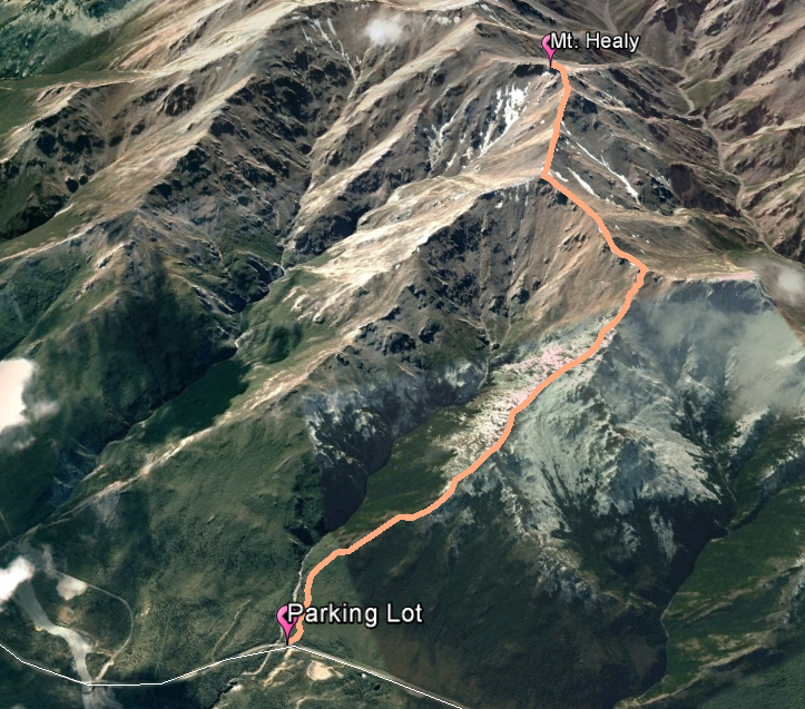
Trek Planner Maps

Trailhead: 63°48’18.24″N, 148°57’14.41″W
First Outcropping of Shale: 63°48’8.18″N, 148°58’36.25″W
”Toilet Bowl”: 63°47’43.32″N, 149° 0’37.53″W
Snow Field: 63°47’13.67″N, 149° 0’17.59″W
Mt. Healy: 63°46’51.09″N, 149° 0’48.62″W

Experience. Discover. Explore.
Follow along on our adventure then go out on your own!


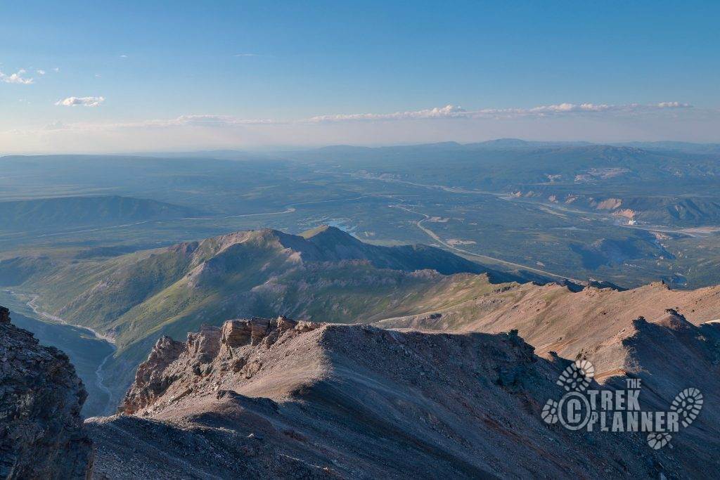
Another view of the trail:
Mt. Healy is my favorite hike in Denali. Even though it is steep the entire way, I enjoy the views this hike offers and you will too! There are many opportunities to view wildlife such as marmots, arctic ground squirrels, pika and possibly Dall sheep so keep an eye and ear out.


You can access the Mt. Healy trail several ways. Hiking from Bison Gulch is simpler than hiking it from the Mt. Healy Overlook trail which begins near the Visitor Center in Denali National Park. Bison Gulch is the most direct route to the top. For a look at the other trails to Mt. Healy click here.
I started the hike in the parking lot just before the Bison Gulch bridge which is located several miles south of the town of Healy Alaska. On the west side of the parking lot you will need to cross over the Parks Highway and follow the dirt trail which begins right at the highway. You will notice that the trail immediately splits toward the creek or climbs up the adjacent hill – follow the trail up the hill and you begin the hike.


The trail goes in and out of the lower elevation trees and shrubs for the first mile or so of the hike until you come to the first large outcropping of shale. This is the place where many hikers turn around back to the parking lot. But we are going to climb to the top! Keep following the spine of the mountains until you come to the very top of the first ridge line.


Let me say that this hike is very steep and many times the trail disappears. You will need to have decent orientation skills but overall if you are in good condition and don’t mind hiking straight up you will enjoy this hike. Just keep a steady pace and rest often.


Once you arrive at the top of the ridge line you will see a small campfire circle. From here you can see the trail continues along the spine in a westerly direction which dips for several hundred yards than heads back up to the next ridge line in about a 1/2 mile. You will cross a large pile of rocks with this boundary post in it (see above picture).


If you are concerned about bear or moose in the area you will be glad to know that once you hit the timber line (which is very low in this particular location) you will be able to see for miles. I have hiked this trail many times and have yet to see a moose or bear on the trail but that doesn’t mean you won’t ever see one. Just be careful and use common sense.
Now, continue on up the trail and you will notice that the trail begins to disappear. As long as you follow the ridge line of the mountains you will be able to get to Mt Healy. The entire length of the trail basically makes an “S” pattern that snakes to the top and as long as you know which mountain is Mt. Healy, you will have no problems. (Mt. Healy looks like a giant rock castle you will see in many of my pictures below)

Above the timber line you might find marmots, ptarmigan, ground squirrels and even pika scurrying about the rocks and alpine fields.


The trail continues to get more and more steep and you will be hiking on talus fields for several parts but I was surprised at how visible the trail was sometimes amidst all the shale.

Eventually you will arrive at the junction where you have an incredible view of Mt. Healy to your left- which is still far away. This is the junction where you could hike the northwestern ridgeline back to Antler Creek if you wanted.
It was here where I found a dall sheep hanging out right next to the trail! He wasn’t scared of me but was curious. I kept my distance even though he walked towards me.


This location also has an incredible vantage point to see the remnants of an ancient glacier which slowly carved its way down the mountain. I call this place the toilet bowl because it looks like, well, a toilet bowl. From here, the trail cuts in a southeastern direction but still follows the spine of the mountain.


I told you that you would be hiking along the mountain spine for most of the hike. You can see the “castle” or Mt. Healy in the background.


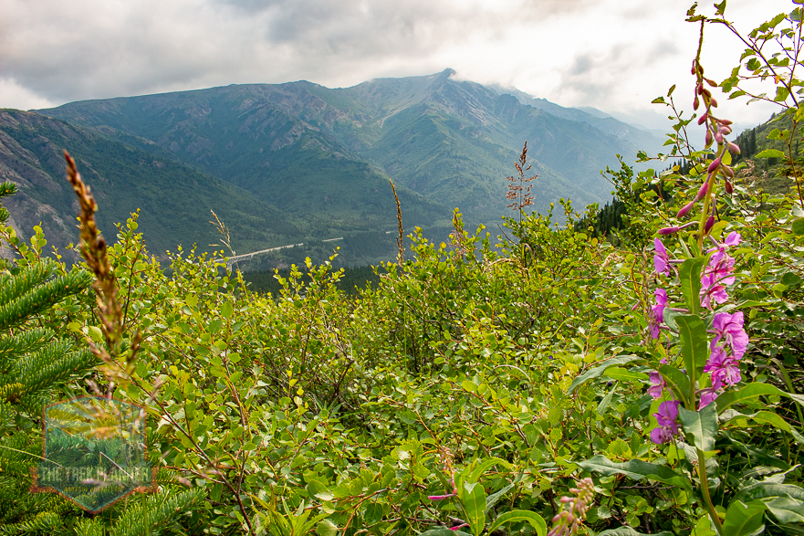
The amount of grasses, moss and even wild flowers blooming this high up and in such a derelict location is quite amazing. It only adds to the beauty of this long hike.

Another remarkable vantage point is this almost rectangular rock that juts out from near the top of the mountain.

The trail sneaks by this little window that overlooks the town of Healy. If you aren’t aware, you will walk right by it.

What seems to go on forever you will finally arrive at a snow field which may be melted if you hike in the heat of the summer. I have found Dall sheep fur and even tracks all over this area so you may be lucky and see some hanging around.


You are getting very close to the top. If you are like me, your legs are probably sore at this point! Press forward!


To reach the summit you will need to hike around to almost the southern side and find a safe way to scramble on the rocks. You won’t need to do any rock climbing but it is still steep and there is loose rock everywhere.

This hike is long and difficult but you will be rewarded with incredible views of the Alaskan Mountain range and on clear days you can see for miles of what is endless wilderness.


The top of Mt. Healy is steep rocky and very dangerous on all sides. If you slip and fall, you will tumble for hundreds of feet before you come to a stop. So please be extremely careful at the top and keep an eye on those you are hiking with.

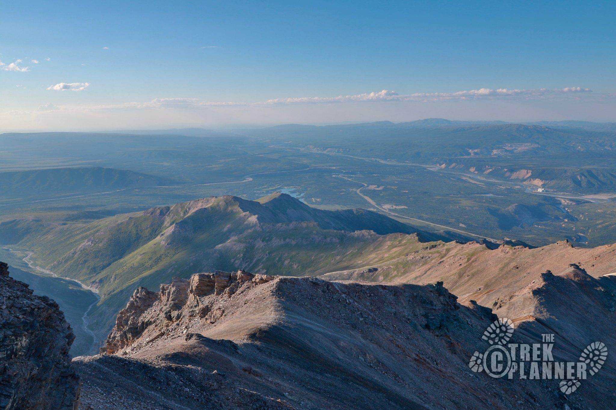
Looking east over the Alaskan Mountain Range. You can see Sugar Loaf and also Dora Peak in the background.

Hiking back down the trail

Beautiful views of the Eight Mile lake on the Stampede trail (road)

Laying down on the soft alpine grass. I was a little more than tired!


I saw some more Dall sheep and lots of arctic ground squirrels on the way down.


Personal Thoughts
The Mt. Healy hike is long and difficult but it is my favorite hike in the Healy and Denali areas. There is something fascinating to me about Mt. Healy. Maybe it's the solitude. Maybe it's the endless terrain of treeless mountains. Either way, I have hiked this about a dozen times in the past years I have been working here and plan to do it even more times in the future. If you are looking for an incredible half-day adventure in Denali, you have found it.


[…] picture below is looking towards Mt. Healy. Mt. Healy is an equally amazing hike and one I would recommend doing if you have the energy and […]
[…] lake, I have found this place to be peaceful and relaxing. There is just something about seeing Mt. Healy in the background along with the spruce and birch trees hanging around the lake edges that makes me […]
[…] Click here to see full Mt. Healy Trek Alaska Denali Denali National Park Healy mt. healy […]